Ever gazed out of an aircraft window and wondered about the people, places and environments flashing by on the ground? The Royal Geographical Society (with IBG - Institute of British Geographers) aims to reveal these “Hidden Journeys†as it combines images and stories in its series of interactive online flight guides.
The Society’s latest route explores the varied landscapes that lie between Hong Kong and Singapore - two of the most important business and financial centres in Asia. Among them you will view two beautiful destinations in Viet Nam including Nha Trang City (Khanh Hoa Province) and the paradise islands of Con Dao (Ba Ria - Vung Tau Province).
 |
|
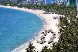
Nha Trang Bay is named one of the top 30 most beautiful bays in the world |
The coastal city of Nha Trang is surrounded by archipelagoes, islands, mountains and white sand beaches. Flying at an altitude of 13,000m, travelers can view Nha Trang nestled on a small coastal plain wedge between the mountain ranges and the sea. In addition, travelers can also see through the window the Central Highlands plateau with its dense forest and rugged peaks which rise sharply from the low coastal plain at Nha Trang and cover a large area.
At an altitude of 2,000m, the tourist hub of Viet Nam becomes visible. Nha Trang Bay is dotted with about 20 islands that make for useful stop-off points on a boat tour, the largest of which is Hon Tre. It is linked to the mainland by the longest oversea cable car in the world.
 |
|
Nha Trang sea front is quickly becoming built up to cater for more tourists visiting the beautiful coast each year |
Nha Trang is one of the most popular beach tourist sites in Viet Nam for its beautiful bay and modern facilities catering for tourists' needs. Nha Trang Bay is named one of the top 30 most beautiful bays in the world. Its seven kilometre long pristine beach is often called Viet Nam's Mediterranean Area, considered one of the jewels along Viet Nam's long stretching coast line. The waters around Nha Trang are full of sea life with abundant coral reefs making this a popular area for scuba diving. In addition, Nha Trang is the finish line for the biennial Yacht Race: VinaCapital Hong Kong to Viet Nam, one of the most challenging races in the world.
Flying to the next spot of the route at sea level, travelers will find 16 mountainous islands form the Con Dao Islands which lie 85 kilometres off Viet Nam's southern shore.
The largest one, Con Son with 80% of the total land area of the islands is protected national park. Con Dao National Park owns both forest and marine protected area and considered one of best examples of marine conservation in Viet Nam, protecting some of the world’s rarest marine life. In addition, for more than a century Con Son Island housed political prisoners during the war of resistance against French and U.S. aggression. Today, the cells are open to visitors to the island.
 |
|
Con Dao is gaining popularity with tourists as its unspoilt beauty becomes revealed to the world |
The Con Dao Islands are also famous for its nice beaches shaded with evergreen trees, fresh air, clear blue waters, and primitive forests. Visitors can enjoy an intact natural environment and have a good time with dugong, sea turtles and dolphins, play freely around the paradise of islands. Coral reefs thrive in the clean, shallow water surrounding the Con Dao Islands. Diving is becoming a popular activity for tourists here.
Con Dao was selected as one of the most impressive destinations in Southeast Asia in 2010 by the New York Times magazine. In 2011, Con Dao was listed in the top 20 most mysterious islands in the world of Travel and Leisure magazine (USA) and was voted as one of 10 best and mysterious islands in the world to enjoy a romantic holiday by Lonely Planet travel guide (UK).
Con Dao is gaining popularity with tourists as its unspoilt beauty becomes revealed to the world.
|
Hidden Journeys has already revealed the breathtaking natural and human landscapes with 18 flight paths. A catalogue of journeys will be built by amazing photos of the places through the flight paths that everyone shares. It is a not-for-profit resource free for public use, and one part of the Society’s public engagement programmes which aim to foster an informed knowledge of our world. |
Compiled by Phuong Anh