As one of the rivers flowing along the borders of the country, Quay Son River as poetic and beautiful as a picture. It runs through the rolling limestone mountains of Trung Khanh District, Cao Bang Province.
Quay Son River is a very poetic and beautiful place. — Photo didauvui.com
In the Sino-Vietnamese sense, Quay Son is a river flowing around the mountain. The river originates from countless small murmuring streams flowing down from the mountains along the length of the Viet Nam – China border, the confluence of two small tributaries from Phong Nam and Ngoc Con communes, forming the magnificent mainstream of Quay Son in Dinh Phong Commune in Trung Khanh. The river flows through Chi Vien Commune to Co Muong Hamlet in Dam Thuy Commune, before reaching the legendary Ban Gioc Waterfall.
The entire river is about 89km long, covering an area of 1,160sq.km. The average altitude of the river is 556m. The section flowing through Cao Bang is 49km long, with a basin area of 475sq.km.
With its persistent internal force, Quay Son River is always full of water, weaving through the limestone mountains. River water from majestic and poetic Ban Gioc Waterfall flows, accreting fertile alluvium on both sides, creating a productive strip of land with lush crops all year round.
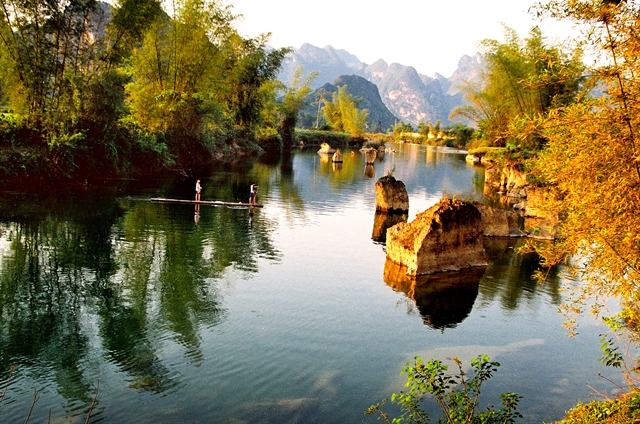
We went to Quay Son River in the early autumn days. Fortunately, the weather was very beautiful. The section of Quay Son River flowing through Co Muong Hamlet, Dam Thuy Commune is very peaceful, flat and beautiful like a watercolour painting.
The weather was cool, the sunlight bright like honey, the sky blue, and the water of Quay Son River as clear as a giant mirror, with silhouettes of stilt houses and lush trees. In the distance, each flap of reed cotton bloomed dreamily on the hillsides, bamboos swing in the rustling wind, ripe rice fields look like a beautiful picture.
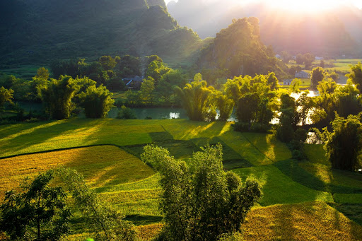
Lush crops grow all year round, thanks to the river. — Photo baotnvn.vn
A bamboo bridge spans the narrowest part of the river, making the scene even more like a painting. Co Muong Hamlet was deserted, with a little sadness and loneliness leaning over the river.
From Ban Gioc Waterfall, we decided to wander up to Ngoc Con Commune to see where the river flows into Viet Nam.
An idyllic, beautiful mountainous region appears on the riverside road from Ngoc Con Commune to Phong Nam Commune. Sometimes going through a spillway, a few young people could not contain their excitement and hurriedly stopped the car, waded into the river, splashed water and played.
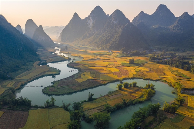
We went up a mountain in Phong Nam Commune to enjoy the full view of the river and mountains. From above, Quay Son gently bends around the rice fields and peaceful houses. In the distance, a stretch of limestone mountains runs to the horizon.
Except for days with prolonged heavy rain, the water of Quay Son River is emerald green all year round. Sometimes we saw a few rafts of fishermen who looked lonely against the immense blue.
While we were busy following the river's flow from one village to another, we suddenly realised a "very Vietnamese" feature on the banks. Bamboo groves have grown on both banks of the river. Bamboos help keep the land, create shade for people to rest, and brings cool wind to the lullabies of mothers in the mountainous areas.
Following the river, soon we reached Ha Lang District where Quay Son River forms a natural border between Viet Nam and China. Sometimes the river bends to China and then back to Viet Nam. The 49km long river section in Viet Nam is considered the most beautiful.
The charming scenery of Quay Son River. — Photo baocaobang.vn
Getting out on the water
To be immersed in nature and feel the wonderfulness when discovering the Quay Son River, some young people go kayaking and Stand Up Paddle Boarding (SUP). In the area of Quay Son River, there are also some places to rent kayaks and SUP. This is a great way to experience nature.
To go kayaking on the river, visitors must go in groups with a group leader, with protective equipment.
According to Nguyen Hai, who used to lead many groups of tourists rowing on Quay Son River, people can only row about 6-10km of the river, from Ban Gioc Waterfall to the Dam Thuy border post, or along other routes such as Keo Na Village – Dit Village, Hang Thoang – Dit Village, Thoong Cot – Dit Village.
At a spillway, after warming up on the shore, the kayaks and their owners launched.
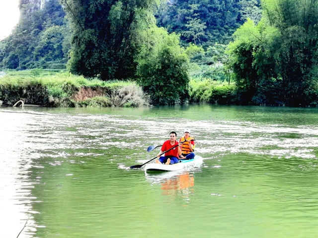
Kayaking is a favourite sport on Quay Son River. — Photo vietnamtourism.gov.vn
"Warming up to let your limbs get used to the water for a few minutes before paddling will help you feel less suffocated when you sit on the boat," said Hanoian Phuong Thuy, who has been passionate about kayaking for several years.
Sitting on the boat, Quay Son River begins to appear with an overwhelming beauty that we can’t feel when walking on the shore. At that time, the bamboo groves, fields, and mountains appear very close. Floating on the deep blue water, in the middle of the vast space, we feel like we are in heaven.
Thanh Giang