A photo exhibition featuring Vietnam's boundary and the country's sovereignty over seas and islands opened in the central province of Thua Thien Hue on November 25.
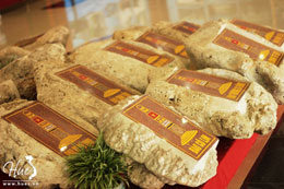
 On display are images contributing to defending Vietnam's sovereignty over the Hoang Sa (Paracel) archipelago and 21 stones taken from Vietnam's Truong Sa island.
Especially, there are historical documents to prove the legality of Vietnam's sovereignty over Truong Sa and Hoang Sa archipelagoes.
They include a 100 year-old map of the China's Qing Dynasty, which defined Hainan islands as China's southernmost (not included Hoang Sa and Truong Sa archipelagoes of Vietnam); the Ministry of Public Works' report on measurements in Hoang Sa under the 19th year of Minh Mang reign (1838); a royal document relating to Quang Ngai's envoy Dang Duc Thiem asking for tax reduction for ships serving mission in Hoang Sa under the 19th year of Minh Mang reign; a royal ordinance relating to Hoang Sa flotilla, under the 15th year of Minh Mang reign (1834), which is kept by the Dang family in An Hai Commune, Ly Son District, Quang Ngai Province and the images of nine tripod cauldrons under the Nguyen Dynasty which engraved Hoang Sa and Truong Sa archipelagoes.
Song albums on the issue and the country's achievements in national defence are also introduced at the exhibition, which will run until November 30.