Upon arrival in Da Nang City, we were recommended to explore Ban Co (chess board) on the peak of Son Tra Mountain, which is 693 meters above sea level.
The two of us went straight to Son Tra Peninsula by motorcycle and found the way up to the mountain following the guidance of local people.
The way up to the mountain peak is a small path which winds up the mountainside and is hidden under forest trees.
Traveling around six kilometers, we hit a T-junction which directs us to go straight ahead to Ban Co peak.
Taking a break at that T-junction, we had a chance to see a great view. The landscape was poetic and romantic and gave us a wonderful feeling. There was nothing but nature around us. Wild flowers in white are almost everywhere on the road surface. In the forest lots of monkeys jumped from trees to trees and took a curious look at strangers.
It was much cooler when we nearly reached Ban Co peak and it was much foggier. We tried to keep calm to finish the rough road with high slopes and dangerous bends.
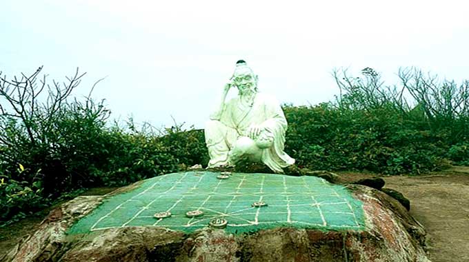
Finally, we saw a board made of cement which reads “Ban Co Peak”. Then, going along a path full of rocks and taking a short climb, we arrived at the peak. There, we saw a statue of an old man sitting by a chess board painted on the surface of a large rock.
Legend has it that two deities used to play chess on the peak of Son Tra Mountain and one day, one of
them lost the game after being distracted by young fairies who came for a bath at Tien Sa beach on the west side of the mountain. Out of frustration, he kicked the chess board to the sea and got back to Heaven. Therefore, local people had painted a large chess board on the rock and built the statue of a deity who sits in front of the chess board, thinking carefully about his next moves. The name of the mountain peak “Ban Co” also came from that legend.
When the sky is clear, this mountain peak is an ideal place for visitors to take a panoramic view of Danang City with Hai Van Mountain, Lien Chieu Bay and the sea far away.
On the way down, we took another path which runs through the forest and is safer. For a while, we saw a helipad used by the U.S. army during the Vietnam War before hitting a radar station which was built by the U.S. in 1965 and used to be called “God’s Eye of Indochina” which could keep track of aircraft departing and arriving within a radius of 300 kilometers.
When finishing that path, we already arrived at Tien Sa seaport and called it an end to the exciting trip to Ban Co peak.